A (not so) quiet walk through the (not so) quiet villages of Java

JogjaHeritageCandiP&Walkers

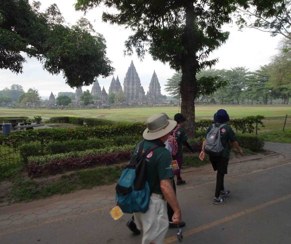
Walkers trudge past the ninth century Hindu temple complex at Prambanan, Central Java

This report is late… in fact more than four months late. This is because of culture shock, I tell myself. I’ve always thought walking was a minimalist, rather ascetic exercise. No frills. No hoop-la. But my mind has been blown to pieces by two days of walking in Java, and I’m having trouble reassembling it.

You see, I signed up for an event called the Jogjakarta International Heritage Walk (see http://www.jogjaheritagewalk.com/) held in November last year. It is one link in a chain of annual two-day walks held across the world under the umbrella of the International Marching League (IML) and the Internationaler Volkssportverband (IVV). I’ve taken part in these walks five or six times in Canberra Australia, and twice in Rotorua New Zealand. They have been quiet affairs run by volunteers, a bit amateurish, 100-300 walkers, a lone barbeque or sausage sizzle and a few cans of Coke for sale. The organisers will give you a free apple or a peppermint Mintie when you finish (if you’re lucky).

Now let me take you to a different planet. We are in Jogjakarta on the island of Java in Indonesia. Here the Two-Day Walk is all bright colours, swarms of people, deafening public address systems, gushing friendliness, mountains of food, countless uniformed volunteers, exotic dances, music, garish advertisements, endless photo-ops, dazzling local culture.

JogjaHeritageMarchingSchoolChildren

School children join in the 2019 Jogjakarta International Heritage Walk…

JogjaHeritagePasukanKraton

…soldiers from the Jogjakarta Palace too.

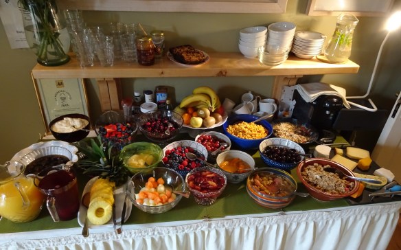
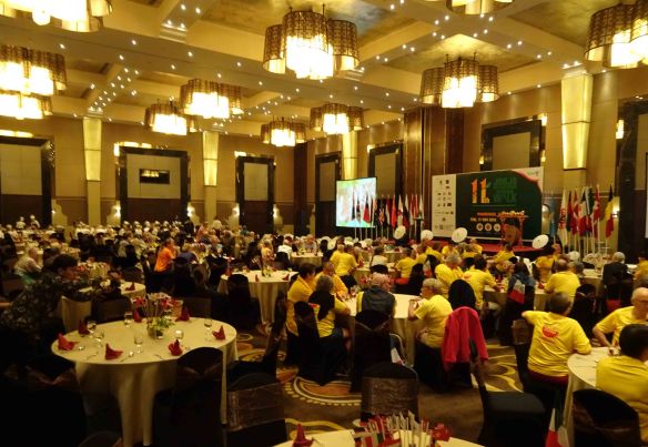
The welcome dinner, on the evening before the first day’s walking, was held in the ballroom of the swank Royal Ambarrukmo Hotel. There was a performance of sinuous classical Javanese dance amid long smorgasbord tables smoking with Indonesian food. An MC introduced the walkers country by country. He talked loud and fast in American-style English with all the over-the-top enthusiasm of a TV cookware salesman. There were big groups from Denmark, the Netherlands, Japan and France, plus many smaller groups and individuals from other parts of the world, including a few bewildered Australians and New Zealanders cowering at the back of the enormous, brightly lit hall.

JogjaHeritagePreDinner

The pre-walk welcome dinner… just a simple snack in austere surroundings.

“Tomorrow, breakfast is at 4:00 am,” the MC shouted. “And be ready to board buses to our starting point at 5:00 am!”

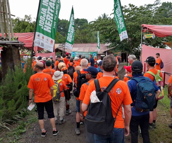
He added a menacing reminder. “And don’t forget… on the first day of walking you wear the green T-shirt… I repeat, the GREEN one, not the orange one!”

We checked our event bags. Yes, we each received two Heritage Walk T-shirts, one dark green, the other bright orange. The following morning, obediently resplendent in my green T-shirt beautifully decorated with the head of shadow-play hero Karno, I boarded a bus with other walkers, and we headed for the ninth century Hindu temple complex at Prambanan, about 25 kilometres from Jogjakarta.

JogjaHeritageAussieFlag

Australians were made to feel very welcome (like every other nationality).

JogjaHeritageQuinnAtStartSelfie

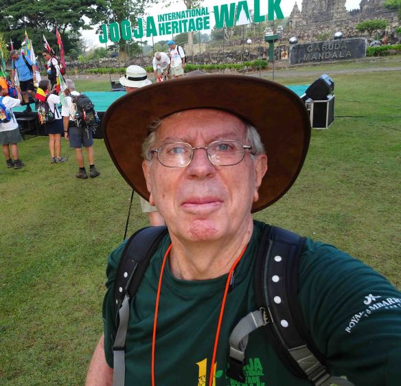
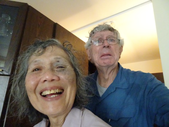
I’m ready to go… a selfie at 6:00 a.m. in the morning.

With the ancient stone temples lowering in the background, we crowded around the start gate, and at 6:00 a.m. sharp, swarmed through it onto a paved path that took us into neighbouring fields and villages. The walking was easy, not too hot at that early hour, and immensely enjoyable. For a short time we were accompanied by a platoon of guards dressed in traditional Javanese military costume. In the densely farmed fields farmers (more women than men) were bent double weeding and harvesting their chilli plants. On the roadside, raw rice lay drying in the sun, spread out on grass mats as farmers turned the grains with wooden rakes. We squeezed past a trackside threshing operation. Sheaves of newly harvested rice were being fed into a chugging machine which, like a small fountain, spouted raw grains into sacks.

JogjaHeritageWalkers&Huller

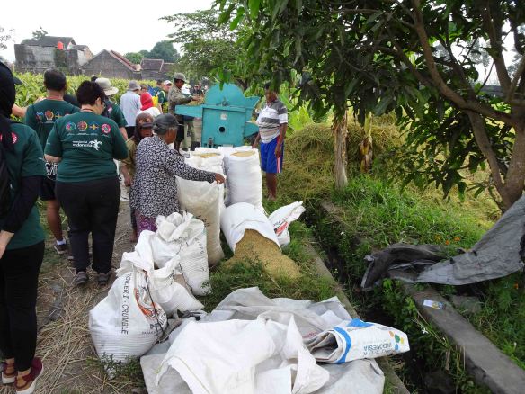
Walkers squeeze past a trackside rice-threshing operation, and (below)…

JogjaHeritageTrackside RiceDrying

…newly harvested rice lies drying in the morning sun.

The path skirted an archaeological excavation. As if coming up for air after centuries underground, a Hindu temple-monument – Candi Kedulan – looked up from the bottom of a large, freshly dug gash in the earth. It was in a remarkably sharp state of preservation, probably protected – like Pompeii – by a shroud of volcanic ash from a forgotten eruption a millennium ago. Already paving was being put in place to accommodate future fee-paying visitors.

JogjaHeritageGalianCandi

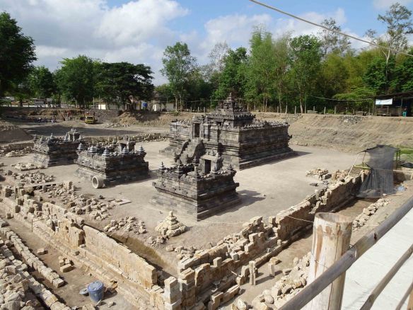
The world of a thousand years ago keeps emerging from the under the earth: Candi Kedulan.

A few kilometres on and I completed the ten kilometre circuit, arriving back in the precinct of Candi Prambanan having covered the distance in a sweaty but leisurely three hours. You might also have chosen a twenty kilometre circuit or a five kilometre circuit. The latter was popular with a remarkable cohort of geriatric Japanese, some with question-mark spines, stringy legs, and very wobbly knees, but also with steely determination to complete their quota of five kilometres.

One woman, probably in her nineties, stumbled and fell. As her companions and Indonesian volunteers crowded around to help her, she fended them off. She rolled on to her hand and knees, folded her legs carefully under her, gripped a walking pole, and levered herself slowly to her feet. She (like many other Japanese walkers) was wearing white cotton gloves. These were now stained with dirt and blood, but she pushed away would-be helpers and walked on (not very steadily) with a defiant look in her eye.

JogjaHeritageDancer

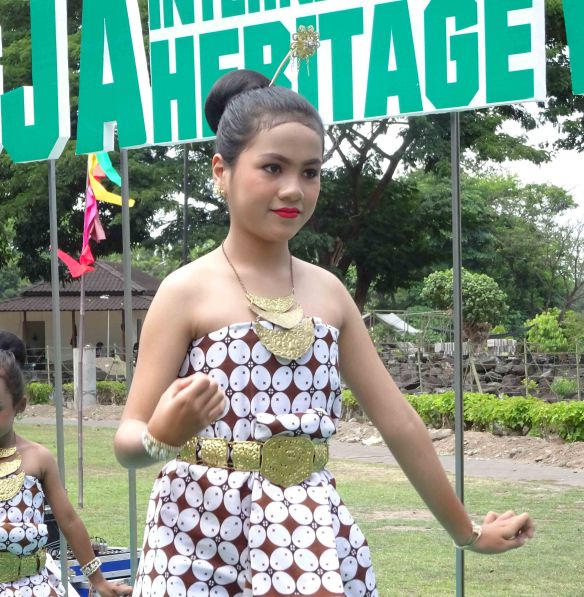
A sinuous, ultra-slow classical Javanese dance performed for walkers by highschool students.

Walkers were greeted at the finish by loudspeakers and entertainment, mostly traditional dances performed on a makeshift stage or on the grass by children excited to be dressed up and showing off. As we watched them we tucked into a simple but delicious Indonesian brunch. We got plied with sweet, psychedelically coloured, rice-cakes too, even thick slices of watermelon dripping with red juice.

Ahhh… the rigours of walking, Indonesian style.

Day Two. Again we were up and gnawing on an extravagant hotel breakfast at 4:00 am. At five o’clock we were in a bus, this time wearing our bright orange T-shirts. As the sky began to glow the bus headed up a steep road to the upper slopes of cone-shaped Mount Merapi. Merapi is one of the most active volcanoes in the world, erupting on average every six to eight years. When it erupted in 2010 more than 300 people lost their lives and a big gash was blasted in the side of the summit.

JogjaHeritageWeAreOffDay2

Obediently wearing our orange T-shirts, we prepare to walk up towards the summit of Merapi.

JogjaHeritageEruptionShelter

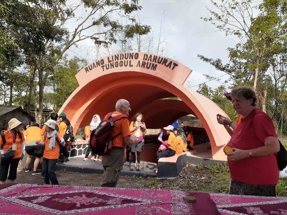
If the mountain erupts, we’re okay. There are special concrete shelters for protection against ash. (But what about hot gas… and big boulders?)

The day was overcast and the early morning air cool at our starting point in the village of Poncoh, about ten kilometers below the summit. At 6:00 a.m. we jostled on to a narrow road that sloped sharply upwards. We walked into a garland of brilliant green: coconut groves, palm oil plantations, second-growth forest. The walking was easy, but the angle of the road quickly dampened our T-shirts with sweat.

JogjaHeritageMuslimTillIDie

JogjaHeritageAjiDiriNotice

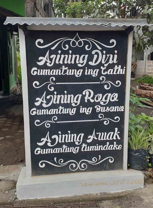
Roadside declarations of cultural/religious orientation. Almost all the people of the mountain are strong Muslims, but Java’s treasury of aphoristic wisdom remains strong too. The plaque reads: “Your personal honour depends on how you speak; Your personal appearance depends on what you wear; Your personal reputation depends on how you behave.”

The path took us through poor but neat villages with friendly people emerging from their houses to enjoy the exotic spectacle of foreigners puffing past, some pushing themselves along with walking poles. Many villagers offered us salak (snakeskin) fruit from their own trees, and coconut milk chopped on the spot from freshly picked nuts. Of course there was the usual price to pay – selfie photos amid a vortex of children and laughter. Can there be – anywhere in the world – more spontaneously friendly and generous people?

JogjaHeritageQuinnWithButo

For once in my life, I’m the best-looking bloke in a photograph.

The circuit brought me back to Poncoh Village around 9:30, three and a half hours later. But the fitness band on my wrist told me I had walked quite a lot further than ten kilometres: 13.26 kilometres to be precise. The distance had passed in a flash. An hour later we were handed a delicious early lunch in a cardboard box. Local children, conducted by their teachers, demonstrated traditional games. These included a kind of dance like the better-known Filipino tinikling. Four bamboo poles were laid on the ground like a hash-tag icon (#), the end of each pole gripped by a kneeling child. Each pair of poles was clapped together alternately in rhythm with a folk tune while other children danced with delicate steps in and out of the spaces appearing momentarily between the poles. (For a stage version of this dance with its nail-biting precision take a look at: https://www.youtube.com/watch?v=lRX_tEJBj5c ) Meanwhile other children fanned out among the walkers trying to practise their English. Given whispered encouragement by their teachers, each was clutching an exercise book with model sentences in it. Some of the French walkers were a bit bewildered. Their English wasn’t much better than the children’s, but they did their best with plenty of laughter.

JogjaHeritageTinikling

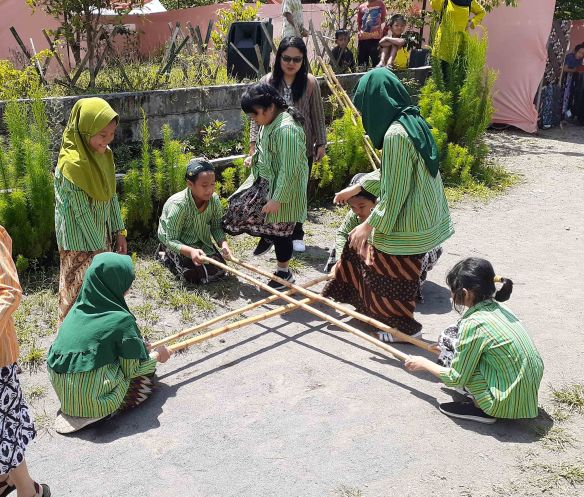
Local students (supervised by their teacher at rear) perform a tricky folk dance. One wrong step and…  A metaphor, perhaps, for the ruthless rigidity of Javanese society?

JogjaHeritagePractisingEnglish

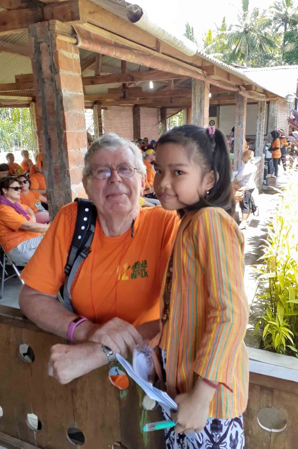
Eleven year old Nur, clutching her prompt sheets, practises English with me.

That night the event closed with an elaborate dinner in a broad pendopo pavilion open to the warm tropical air. It was the usual Indonesian amalgam of rigid formality and laughter-filled informality. A small band played kroncong music, a genre born out of Java’s distant connection with Portugal. The music flowed with noctural tenderness from a violin, flute, ukulele, guitar and cello. (Get a small taste of this simple, beautiful music at: https://www.youtube.com/watch?v=a8lKKOypnMU )

Each walker was summoned – together with other walkers from the same country – to receive a diploma and the Two-Day Walk medal. To the accompaniment of gentle kroncong music and the flash of a hundred smart-phone cameras, I too ducked my head as the ribbon was placed around my neck.

Indonesia does walking its own way, and after putting aside my culture shock… I like it!

JogjaHeritageQuinnWithMedal

At the closing dinner, I show off my medal.

Advertisement

At the Western Edge of Europe (3): We skirt the “vast cracked pavement” of the Burren hills

dsc01103.jpg

Emerald green and grey, the colours of the Irish countryside along the Burren Way, here exemplified in shamrocks…

dsc01143-e1565491536207.jpg

…and rough-cut stone walls.

On the morning of July 24th Emmy and I walked out of Doolin heading for the seaside hamlet of Fanore, twenty kilometres to the north. It was a quiet day of unremarkable walking, just what we needed after the small stresses of the previous two days. Our path took us inland through pastureland, along deserted village roads between hedgerows of tangled blackberry and endless low walls of rough-cut stone. The temperature was a cool seventeen degrees. The sky hung over us low and grey, sending us two short sharp showers of misty rain. From the high slopes above the coast we could look out over the Atlantic Ocean and see the blurred spectres of the Aran Islands stretched along the horizon.

DSC01107

The view out to the Aran Islands from the Irish mainland between Doolin and Fanore in County Clare.

DSC01111

The walking was quiet and easy, between kilometres of stone walls through treeless pasture.

The sea wind muscled in through the open front door of our B&B in Fanore, rattling doors and filling the big house with a subdued howling and groaning. We dined on the deservedly famous fish and chips at O’Donohoe’s pub, and (with the front door of the B&B shut and the house silent) we slept soundly. The following day dawned dark. A glance from our bedroom window revealed rain sparkling on sheets of water along the coast road. Today we would not be walking over miles of slippery flat stones in the treeless expanse of the Burren hills, aptly described as “a landscape of bedrock incorporating a vast cracked pavement of glacial-era limestone”. Around midday, huddled against bullying showers, we stood opposite O’Donohoe’s pub and flagged down a local bus for the twenty kilometre trip to our next stop, the neat little town of Ballyvaughan on the southern shores of Galway Bay.

Burren karst

The rocky Burren hills. Not for us… at least not on a day of misty rain. (Photo by Fish Cop, Wikimedia public domain)

Our B&B – the Ballyvaughan Lodge – was one of the most welcoming, most comfortable and best run we have stayed in during our many years of multi-day walking. Our host, Gerry, was more than welcoming. He took the trouble to immediately learn the names of all his guests and always addressed them by name. He served a very special breakfast on tables with starched tablecloths and serviettes embroidered with the house initials. The tea even came in porcelain teapots kitted out in woolen cozies. The breakfast omelette “with the lot” – prepared by Gerry’s wife Pauline – was the best omelette I have ever tasted, far surpassing that served in the five-star Dublin hotel where we stayed the following week. Emmy ordered “soldiers” (without really knowing what they were). The soldiers turned out to be fingers of toast that came with a soft-boiled egg served in its own little woolen beanie. When the top of the egg was sliced off, the bars of toast were dipped into the soft yolk and lifted in your fingers to be eaten. Emmy found this dish so unbelievable that she ordered it again the following morning just to reassure herself it was not a kitchen accident, or a figment of her imagination.

dsc01148.jpg

Breakfast at the Ballyvaughan Lodge, and this was just for starters!

dsc01152.jpg

Toasted “soldiers” with a soft-boiled egg under the beanie to the right.

So it took a special effort for us to lace up our boots, fill our water bottles, shoulder our backpacks, and head out for the final day’s walk on the Burren Way itinerary. It was a loop walk that snaked ten kilometres through woodland and deserted backroads past the vast “cracked pavement” of the Burren hills, returning us four hours later to our beginning point in Ballyvaughan. The walk turned out to be a little more demanding than we expected. It was well way-marked, and we had a good map and instructions, but we had to keep our wits about us. The problem was the lush growth of summer grass that concealed the track in several places, plus the week’s non-stop showers that, here and there, had erased the track under runnels of mud. Several times I consulted our GPS phone app to check our position and get back on track after straying off the route.

Ballyvaughan map

Our map of the Ballyvaughan Wood Loop. The left side of the heart-shaped loop was mostly woods and pasture, tangled and wet on the day we walked it. The right side was quiet farm roads. The halfway point of the walk was the Aillwee Caves (bottom centre) where we stopped for lunch. Ignore the 2:30 hours estimated duration of the walk in the top line. It took us more than four hours, although this did include a light lunch at the Aillwee Caves.

DSC01126

Here be leprechauns, banshees and fairies. Note the way-markers on the right.

dsc01132.jpg

An unexpected danger. Apparently the chickens of Ireland are particularly vicious.

But it was a very satisfying final outing. That evening, as we dined on juicy lamb shanks in Ballyvaughan’s Wild Atlantic restaurant, we were able to look each other in the eye and say “we did it!” We walked for a month through Germany, France and Ireland. A few times we took short-cuts or traveled a segment of our route by bus or taxi, but altogether we had walked about 160 kilometres. We had toughened up, we had enjoyed extraordinary hospitality, we had seen beautiful sights and eaten good food (and some truly terrible food too) and met many warm personalities. We had also been mentally challenged (travel and hiking are always a bit unpredictable), we had been invigorated by the sweetness of solitude and each other’s company, and we had lost weight (though not a lot). Now it was time to head home to the chill of Canberra’s winter.

DSC01175

Mission accomplished. We’re on our way home, but we’ll be coming back.

DSC01157

With Denis, on a detour to show us the views over Galway Bay. For the instant required to take this photo, Denis stopped talking. In the space of one hour with him, we learned everything about Ireland, from superannuation to immigration, to foreign policy, to the impact of Brexit, to divorce and the Catholic church. It was a pleasure to be his customer.

As we lifted off from Dublin Airport I saw before me a gallery of the Irish people we had met since touching down at Shannon. Declan who drove us from Shannon to Liscannor and insisted on wrangling our two heavy suitcases, one by one, from the boot of his taxi twenty-five metres through light rain into the reception desk in the Cliffs of Moher Hotel; the effusively warm Kimberley at the Cliffs of Moher Hotel, originally from California but now more Irish than the Irish; PJ at the Seacoast Lodge in Fanore who told me that, with the name “Quinn”, I was more Irish than he was (I barely understood his heavy Irish accent); Gerry and Pauline, hosts extraordinaire at the Ballyvaughan Lodge and custodians of the world’s best breakfast; and the garrulous Denis who drove us from Ballyvaughan to Galway railway station, taking a lengthy detour at no extra cost to show us scenic panoramas we would never otherwise have seen. Plus the nameless young woman who jumped from her car when she saw us consulting our map at an intersection outside Doolin. She had auburn hair with ginger highlights, bright hazel-green eyes and a pasty-white complexion studded with freckles. In short, an epitome of Irish beauty. She had even painted her fingernails shamrock green. She quickly set us on the right path, recommending the fish and chips in Fanore as she sped off.

Emmy looked wistfully out the airplane window. “Let’s come back,” she said. It was the very first time she had ever said this at the conclusion of a walk.

DSC01119

I reconnect with my heritage in the main street of Ballyvaughan.

At the Western Edge of Europe (2): The Aran Islands

dsc01106.jpg

At the top of the photograph, Inishoirr (also often spelled Inisheer), the nearest and smallest of the Aran Islands, as we saw it from a high point on the Irish mainland…

dsc01097.jpg

…and our first glimpse of the island’s austere skyline as we came ashore from the ferry.

It beats me how the Aran Islands can be such a huge tourist attraction. They lie like three low, grey-green mounds in the sea, shorn clean of trees by the Atlantic’s incessant gales. A few grim ruins decorate the crests of the islands. There are one or two pubs plus some small shops. And that’s about it… at least for all except specialist historians, archaeologists and anthropologists. The big attraction of the islands – their wind-swept isolation – has disappeared under a tsunami of tourists, at least in summer. I blame the wildly popular, satirical sitcom Father Ted. Its kick-arse Catholic mayhem happens on a fictional island in the Bay of Galway. We know where that “fictional” island is… the opening credits were filmed on the Aran Islands (type “Father Ted” into YouTube’s search box.)

Our walking itinerary (see Macs Adventure: https://www.macsadventure.com/holiday-2183/best-of-the-burren-way ) mandated an eight-kilometre circuit through part of the biggest island, Inishmore. On the morning of July 23rd we walked from our comfortable B&B accommodation in Doolin to Doolin Pier one kilometre away along a narrow road already choking on tourist buses. We had tickets for a ferry ride to the islands, but chaos was in charge at the pier and I couldn’t identify our boat. No signs, no announcements, just big groups of people disintegrating, regrouping and disintegrating again. I saw an official-looking lady in a hi-viz red jacket pointing left and right.

“Good morning,” I said politely. “How are you this morning?”

“Sure I’m livin’ the dream,” she said, laying on the irony like a thick blob of cream on an Irish scone.

I flashed my ticket and raised my eyebrows.

“Your boat’s the Galway Girl. There she is, down there at the jetty.”

And indeed the Galway Girl was heaving and rocking and making ominous splintering noises against the jetty. Its gangway sloped down to the concrete of the jetty where it slid out and back as the boat rocked on the heaving sea. A grizzled old salt – complete with woolen beanie and thick beard – straight out of a winter advertisement for cough drops, was helping passengers get a foothold on the constantly moving bottom steps of the gangway.

Galway Girl

The Galway Girl, the ferry that took us from the mainland to Inishoirr. (Photo: Shipspotting)

It was a rough forty-minute crossing to Inishoirr, the nearest and smallest of the three islands. White-capped waves banged against the hull as the boat sawed through them. They wrenched and yanked at the boat, heaving it up and slamming it down into the rock-hard water. As we crept up to the jetty on Inishoirr Emmy and I were feeling queasy.

ireland-aran-islands

The scattered houses of the main settlement on Inishoirr.

“Passengers for Inishmore, please transfer to the neighbouring ferry,” said the PA announcement. The onward trip would take another hour, to be followed by an eight-kilometre walk on Inishmore and one-and-a-half hours back to the mainland on rough seas.

Well… to be honest, this didn’t appeal, so we got off and headed up a concrete ramp into the sole small village on Inishoirr. A hundred or more people had the same idea. They surged into ranks of horse-drawn traps, buggies and bicycles. With genteel brutality a hand-to-hand battle for customers broke out.

Pony trap Aran Islands

Pony traps are a popular way for visitors to see the island, and a good source of income for islanders during the summer tourist season. (Photo: Nadia Prigoga-Lee, Flickr)

We decided to walk around the scattered houses of the village. At the edge of the village (it wasn’t far) we came across the half-exhumed ruins of a 10th-century church, the burial place of Saint Kevin, the island’s patron saint. Near it stood the island’s modern church, a simple, white, far-from-historic building. For us, it was a welcome capsule of quiet a world away from the confusion of bikes, horses, buggies and people around the jetty. All its signs and devotional materials were in Irish. In several corners, devotional candles burned with subdued brilliance, seeming to symbolise the modest but steady faith of the islanders.

DSC01095

Inishoirr’s modest Catholic church.

DSC01092

The quiet, (almost) tourist-free, interior of the church.

DSC01084

Emmy lights a candle (25 cents each) but refuses to say who, or what, the candle is for.

Aran parish newsletter2

The July 2019 edition of the Aran parish newsletter. The Aran Islands are part of the Gaeltacht, a string of Gaelic-speaking communities located mostly in isolated parts of the west coast.

Refreshed, we walked on to a modest cottage in a narrow lane. One half was a tiny café, just four tables jammed one against the other. We inserted ourselves into chairs under a table and ordered scones and tea from the blackboard menu.

“Sorry, we only have one scone left. Plus a strawberry cheesecake pie.”

DSC01096

The tiny cafe and crafts shop where we had a scone and a cheesecake pie for lunch (behind the window on the left). I bought a handmade woolen sweater in the small shop on the right. The sign in Irish reads “The Craft Shop”.

That was our lunch. We ate slowly, enjoying the exotic resonance of the Irish language as the young waitress and waiter struggled to prepare a pot of tea and locate some butter and jam to serve with the scone. They told us, with great pride, that Irish was their everyday language, as it was for most of the fewer than 2,000 permanent inhabitants of the Aran Islands. In the neighbouring room, an array of Aran knitwear was on sale. Sweaters, cardigans, scarves, beanies, throw-rugs all beautifully handmade from soft, thick, locally spun tweed wool. It was a warm day, but I couldn’t resist buying a winter sweater. (I’m wearing it right now as I type these notes, snug and well-insulated in the frigid ambience of Canberra’s Aran-like winter.)

DSC01176

My beautiful, locally hand-knitted sweater with a hand-written label.

Our visit to the Aran Islands lasted just four hours, but it was long enough for us to peep for an instant behind the billboard of tourist hype that hangs over the islands and see a unique way of life centred on the Catholic church, the Irish language, and flourishing home craft industries.

At the Western Edge of Europe (1): The Cliffs of Moher

Burren Quin sign

Between Shannon Airport and the village of Liscannor, a roadside sign points to a trace of my Irish ancestry in the village of Quin.

It was my first visit to Ireland. Emmy and I went by taxi from Shannon Airport to the township Liscannor on the Atlantic coast about one hour away. We passed roadside signs pointing to the village of Quin. A strange feeling came over me. It wasn’t deja vue exactly, but rather a vague feeling of familiarity. Perhaps this is where my ancestors came from. I don’t know much about them except that they fled Ireland around 1870, initially settling in the lowlands of Scotland, then migrating to Canada and later to New Zealand where I was born. Quinn – with its variants Quin, O’Quinn, O’Coinn, Cuain, Cuinche and others – is a common Irish name found right across the island. It is especially common in County Clare where we saw it on several signs as we walked the Burren Way up the west coast. Unexpectedly, I found myself walking on what might have been my family’s ancient home ground.

Burren Quinn Abbey

Quin Abbey in County Clare. This tumbledown ruin and me… we have a lot in common. (Google Earth image)

On the morning of July 22nd, with a blustery wind slapping at us from the chopped-up waters of the Atlantic Ocean, we shouldered our backpacks and headed out of Liscannor towards the southern end of the famous Cliffs of Moher. We were on a track called The Burren Way. Our destination for the day was the hamlet of Doolin, about twenty kilometres to the north. We walked into green pasturelands, criss-crossed by rough stone walls, that sloped down to a grey sea. Isolated white cottages crouched in the grass with beige-coated cows dotted around them. There were no trees, the roads were empty, and the homesteads too seemed deserted. We walked alone.

dsc01066.jpg

The famous, windswept Cliffs of Moher.

DSC01062

Emmy braces herself against the Atlantic wind with O’Brien’s Tower in the background.

dsc01067.jpg

Rough slate walls helped protect us at the edge of the cliff.

Our walking poles came out early. We levered our way up a long, gravelly asphalt road towards a ruined stone tower – O’Brien’s Tower – standing high above the sea. From there, looking north we saw a series of steep dark headlands diving almost vertically into the sea. The path narrowed and veered towards the edge of the cliff. Far below, the white breakers of the Atlantic boiled against the rocky teeth of the cliff base. In some places big slabs of slate had been placed like a low wall between the path and the edge of the cliff. We had to wobble over at least half-a-dozen stone stiles.

DSC01059

Stone stiles… my technique was to sprint up to the stile, leap high into the air, and soar over it in one youthful bound (as illustrated in this photo).

We met a few walkers coming south, and as we crept north more and more of them appeared. About twelve kilometres from our start-point in Liscannor – a bit over halfway through our walk to Doolin – the crowds thickened. Again and again we had to press ourselves against the side of the path to let them past. The path widened to accommodate a horde of day-trippers: howling toddlers in pushchairs, fat Americans wheezing and dipping into bags of potato crisps, teenagers daring one another to take selfies at the cliff’s edge, clusters of Spanish tourists talking among themselves earnestly, intently, rapidly and non-stop as they walked, indifferent to the natural spectacle around them.

dsc01068.jpg

Teenage day-trippers dare one another on the cliff’s edge.

Then, in the distance, we saw where they were coming from: the Cliffs of Moher Visitor Centre (called, I’m sorry to report, “The Visitor Experience”). To keep it unobtrusive, the Irish authorities have hidden it under the flanks of a grassy hill. But the parking area cannot be hidden. Its hundreds of cars and buses glisten like a bright, ugly, constantly mutating melanoma on the green skin of the landscape.

dsc01070.jpg

Like a melanoma on the skin of the landscape: the jam-packed parking area at the Cliffs of Moher Visitor Centre. Note the crowds of day-trippers walking the edge of the cliff.

The Cliffs of Moher are one of Ireland’s most popular tourist attractions. They bring in a clutter of mobile phones, baseball caps, over-sized sunglasses, and headphones whispering to the outside world the deafening thumps of music that fill the heads of their users. The cliffs are an interesting natural phenomenon, even spectacular in places, but most visitors scan them quickly, and with a curious indifference, before recording some photos and heading back to the Visitor Centre. The cliffs are a “celebrity location”, famous, above all, for being famous. You go there in order to say “I have been there.”

Travel, they say, broadens the mind. But modern mass tourism seems to do the opposite. It actually narrows the mind. It reduces, and tries to monopolise, options, flexibility and contact with local people. Travellers are whisked from site to site in buses or cars, given pre-digested “information” about each site, allowed photo-ops, then delivered to gift shops. This kind of travel is just another form of consumerism… you collect destinations and take them home in your mobile phone like selfies with sports stars and the autographs of media personalities.

What’s worse, because of tourism’s indifference to the celebrity locations it promotes, it ruthlessly exploits, and ultimately destroys, them. Mass tourism means getting close to the fame of a place – however fleetingly – without bothering yourself with the origins or meaning or authenticity of that fame. Barcelona, Venice, Amsterdam, Jerusalem’s Old City, the Eiffel Tower, the Tower of London, the Colosseum, the Parthenon, the Louvre – hundreds more – have become unbearable ant-hills of people, offering little more than glimpses of history, or greatness, or beauty amid a relentless crush of people, and a litter of souvenir shops and fast food outlets. Tragically, this is what many tourists expect, even what they want.

If you like hiking – long distance walking – it is probably because you enjoy solitude. How can the travel industry sell solitude to a mass market? It can’t, of course, except by redefining solitude to mean lots of people, but fewer than at the Cliffs of Moher. So real solitude is deleted from the mind-broadening options offered by the travel industry, even as simultaneously they broadcast (or imply) the slogan “travel broadens the mind”.

But back to the Burren Way. At the end of a long day’s walking – a bit stressed by the necessity to walk some segments along narrow roads between thick blackberry hedges, mixing it with long lines of cars and tourist buses that filled the whole width of the road – we trudged into the tiny hamlet of Doolin, famous for the traditional Irish music of its pubs. And yes, that night, as we tucked into a rack of lamb in O’Connors Pub, we listened to a harp and bauzouki duo in one corner of the dining room playing a selection of gentle traditional melodies. My stress and annoyance at the Cliffs of Moher’s “visitor experience” melted away. The mashed potatoes tasted especially good with a pinch of salt and a knob of rich Irish butter on them.

DSC01100

The tiny hamlet of Doolin, justly famous for the traditional Irish music played in its pubs. Our B&B accommodation was just past the left end of this strip of shops and pubs.

Burgundy in summer: We walk from Dijon to Beaune through the endless vineyards of the Cote d’Or

DSC00947

Old buildings and narrow streets in the centre of Dijon.

Our first surprise was the city of Dijon. For me Dijon used to mean just one thing: mustard. Dijon mustard goes on your barbie snags (that’s “barbequed sausages” for readers unfamiliar with Aussie idioms). You can get it at Woolworths. What punishment could possibly fit this ignorance? Dijon, we discovered, is a picturesque, historic city. Its centre is crammed with beautiful buildings: palaces, museums, churches, creaky old residences reminiscent of England’s Tudor heritage. It is a meditative pleasure simply to stroll the criss-crossing, zig-zagging pedestrian walkways of the city centre.

We got a taste of Dijon’s old-world character at the Petit Tertre Hotel, our night’s accommodation. “Hotel” doesn’t quite cut it as a term for a dark maroon door in a wall. No signage, just a street number. Behind the door we rolled our suitcases down a dark, stone-walled corridor with several doors on the right leading into (presumably) apartments of local residents. We emerged into the sunlit floor of a square well with a patch of blue sky far above us and bicycles leaning against its walls. We disappeared into another stone-walled corridor to emerge from its dimness into a tiny courtyard with a short narrow, stone staircase climbing the side of one of its walls. At the head of the staircase we found our room. It was as eccentric a “hotel” room as one could wish for.

Tertre1

The façade of our “hotel” in Dijon. Our comfortable, antique room was down two long stone-walled corridors behind that unassuming door.

In the centre of the room stood a dark, round, varnished dining table with a simple but exotic chandelier above it. Behind it was an upholstered chaise longue. Next to this stood a tall, antique, folding screen decorated with 18th century motifs. Partly hidden behind it was a bed heaped with cushions and blankets. At the foot of the bed stood the room’s piece de resistance, a “wardrobe” yet not a wardrobe. It was a 19th century traveller’s clothes trunk with huge hinges and iron latches. About a metre high, it stood on one end, its top-to-floor mouth partly prised open to reveal a space where clothes might be hung. Up some steep, rickety wooden stairs there was a mini-mezzanine loft with a double bed filling most of it under a gable-topped window looking out over slate-tiled roofs.

The next morning our host served us breakfast on the varnished dining table: deliciously flaky croissants, freshly baked bread rolls, jams and soft cheeses and fresh yoghurt. And of course, strong aromatic coffee. We were magnificently set up for a day’s walking.

Great grapes statue

And here’s where we began… beside a statue of the “Bearers of the Great Grape” just outside Dijon. It encapsulates the all-consuming role that wine has in the culture of Burgundy.

Following instructions by Macs Adventure (https://www.macsadventure.com/holiday-2231/burgundy-short-break-dijon-to-beaune) we were taken by taxi to the edge of Dijon where we started walking at a bronze statue labelled The bearers of the great grape. It was the morning of Monday July 16th 2019. Already the day was uncomfortably warm. Within hours, as we climbed up into the part-wooded slopes of the Cote d’Or, the temperature had topped 30 degrees. We looked out across a shimmering landscape of endless neatly combed, bright green ranks of grape vines punctured by spiky old churches, shuttered deserted villages, and turrets of the occasional chateau. We were walking on a surface that was part quiet country road, part asphalt path and part gravel track. We made sorties into hill-top woods with their crackling leaf-strewn tracks and shadows of cool. Macs Adventure had supplied detailed trail notes, maps and a mobile-phone app, and the route was reasonably well way-marked.

DSC00971

Vines, villages and vistas… our Burgundy walk in a nutshell.

dsc00955-e1564170632245.jpg

Colourful ceramic tiles decorate many church spires in Burgundy.

dsc00973.jpg

Exotic buildings dot the countryside. Our route passed close to this one, the Chateau Clos de Vougeot, near the village of Chambolle-Musigny. Centuries ago it was a Cistercian monastery producing wine that helped put Burgundy on the map as a centre of viticulture.

The end of a long day led us to the small town of Gevry-Chambertin. Tiny though it was, it seems every second shop was a “cave” – a cellar-shop selling wine. We dined in the evening warmth at the Chez Guy restaurant. When the proprietor asked: “And to drink, monsieur? What is your preference? Red or white?”

“Just water for us, thanks.”

His shock lasted less than a nano-second. Maintaining perfect courtesy in the face this foreign eccentricity he asked:

“Still or sparkling?”

Having tucked into a delicious fillet of Burgundy beef we sat in the quiet square opposite an old church with its bell clanking at quarter-hour intervals, sipping our austere ration of (still) water, and enjoying the long slow sigh of twilight as it breathed its warmth into the approaching night. I’m reluctant to say this, because it sounds so sentimental, but it was the perfect end to a perfect day’s walking.

DSC00964

Emmy’s shadow stretches out beside her as we set off early in a futile attempt to avoid the 30 degree heat of the second day’s walk.

And Day Two was pretty much like Day One, only hotter. We left Gevry-Chambertin around eight o’clock in the morning, hoping to cover as much distance as possible in the cooler air of morning. And again, like riffling the pages of a souvenir calendar, we flashed past vineyards, turreted chateaux, church steeples ceramic-tiled in colourful patterns, villages with their shuttered town halls and their wine shops displaying sample bottles on upended barrels along the footpath. And this time, in the square of Nuit-Saint-Georges, I demolished an entree dish of six snails. The very ample lady at the next table made short work of sixteen.

DSC00985

Snails for your entrée, monsieur? Mais oui!

DSC01006

And roast duck to follow? With a glass of burgundy white? You bet!

DSC00982

Our accommodation in Nuit-Saint-Georges was cramped to say the least. I couldn’t stand upright in the loft bedroom.

The idyll couldn’t last, of course. It came to an abrupt end on Day Three. Heading out of Nuit-Saint-Georges, we got lost. Twice. Our trail notes told us to look for a small forest path, but developers had been into the forest. Raw earth and smashed trees lay heaped where our path was supposed to be. We tried to peer over the debris and walk around it, but saw no sign of any path. Half an hour of poking around led us back to the edge of the forest. I looked down the valley slope, over the endless ranks of grape vines, to a country road a couple of kilometres below us. It was our way out. Half an hour later we were inching cautiously along the side of the narrow road toward the village of Ladoix-Sevigny where (our map told us) we could reconnect with our planned route.

And yes, we managed to do that. But after just fifteen minutes of trekking through vineyards we were lost again. Maybe the configuration of the vineyards had changed, or our trail notes were not precise enough, or (no… this cannot possibly be the reason) I had forgotten to recharge my mobile phone and couldn’t access the route on Mac’s online app. Whatever… we found ourselves trudging the streets of a small town looking for a landmark. We walked past a middle-aged lady chatting on the footpath to a young man on a motorbike.

“You are visitors!” she called to us good English. “Where are you going?”

“I’ve no idea where we are going,” I called back. “We’re lost!”

“Come into my garden,” she said. “I’ll explain everything.”

DSC00988

Emmy with our “Dame du Chemin”, Sabine, in the back garden of her house in the village of Ladoix near Beaune.

She pressed a button on a handheld remote, and behind her, in a high, grey wall, a tall slab of iron creaked slowly open. She ushered us onto the back verandah of a grand old house set amid trees in a lush garden with a tennis court and a glassed-in swimming pool. Three big dogs bounded up – each dribbling over a stick or pine-cone – demanding to play. Big glasses of icy water appeared before us as Sabine, our new-found guardian angel, launched into an epic account of her family, her late husband’s business interests, her house, her children, and her dogs. An hour later, as she paused to draw breath, I glanced at my watch and, half-rising to my feet, murmured our thanks.

“Where are you going?” she asked in astonishment.

“We are walking to Beaune.”

“You certainly are not walking! I will take you there in my car!”

And that’s what happened. Not only did she drive us the last five kilometres to Beaune, she also took us to the nearby chapel of Our Lady of the Road (Notre Dame du Chemin) which has been part of her family’s heritage from ancient times. Half the chapel dates from the 11th century. This was followed by a tour around the streets of Beaune before we were delivered to our accommodation at Beaune’s Belle Epoque hotel.

DSC00989

Sabine shows us the chapel of Our Lady of the Road (Notre Dame du Chemin).

That night, we drank a quiet toast of burgundy in thanks to Sabine, our dame du chemin. We were sitting in the Ecrit Vin restaurant (another family establishment recommended by Sabine) in the central square of Beaune, allowing the gentle rhythms of a jazz recital to wash over us from a nearby gazebo. Yet again we sank gratefully into the French institution of a long slow outdoor dinner, with long slow sips of wine, in the quiet warmth of a long slow summer twilight.

Have the French got it right? In Burgundy, in summer, yes, they have.

Postscript: A Perfect Stay with Friends in Charolles The following day we sailed south for an hour on a local train to the town of Macon where we were met by friends Lois Belton and Georges de Lucenay who live in the nearby town of Charolles, famous for its beef cattle. And again we luxuriated in the best of French hospitality: great food (I can still savour your Coronation Chicken, Lois), the warm quiet streets of Charolles, 17th century music from the town’s new church organ played with stately perfection by Lois, and a long, peaceful sleep under the 2nd floor roof of our friends’ big old house. Lois (originally from New Zealand) has adopted the splendid eccentricity of taking breakfast with a rook perched on her shoulder. Its intelligent, beady eye – like a guardian of all things Burgundian – kept a vigil over our meandering conversation and our slow enjoyment of croissants, local cheeses, local fresh eggs, and Georges’ delicious home-baked bread. It even forgave my swigging of Coca-Cola, a sin that must be kept secret in the wine country of Burgundy (wise bird!).

DSC01030

Lois takes breakfast with her dark guardian…

DSC01020

…before bringing to life the solemn faith of former times at the keyboard of the beautiful new organ in the town church of Charolles.

DSC01039

Emmy and Lois  check out a chateau with its moat in the small town of La Clayette, near Charolles.

Next Post: we walk the wild Atlantic coast of county Clare in Ireland.

Germany’s Romantic Road (Second Half): Dinkelsbuhl to Nordlingen

DSC00875

The view from our hotel window in Dinkelsbuhl, and below…

dsc00886.jpg

… the hotel itself (centre) with an open-air café in front of it.

Dinkelsbuhl is a remarkable town. Its walled centre preserves an astonishing array of wide-fronted, multistorey houses with peaked, steeply raked roofs dating from the 16th and 17th centuries. They stand in packed ranks along the town’s narrow streets. Most are neatly painted in pastel colours – creamy yellow, light orange, beige, moss green. Some stand out in scarlet, lemon yellow or brilliant white. Outwardly they are beautifully maintained with few concessions to the 21st century, but behind the neat facades everything is impeccably hi-tech and modern.

Somehow Dinkelsbuhl avoids being Disney-tacky. The locals are not decked out in faux-medieval costumes. The streets are narrow and cobbled as they were 500 years ago, with, in some cases, houses leaning over and looking down into them, each successive floor overhanging the one beneath. Public signage is in German gothic script. The Brothaus bakery – where we twice feasted on sweet pastries and cake-like bread rolls – tells customers it has been doing business in the same spot since 1616. A soaring 16th century stone church – St.George’s Minster – stands at the hub of the town.

We took a tour of the town in a large roofed cart pulled by two giant horses. As the waggoner – who was also our guide – waited for his cart to fill with customers, from time to time he took a sip from a huge glass of beer, each time returning the glass to its storage place under his seat. Apparently the prohibition on drink-driving doesn’t apply to horse-and-cart drivers.

dsc00896.jpg

The narrow streets of Dinkelsbuhl seen from a horse-drawn cart.

An unpleasant incident occurred during the tour. As we clopped at walking pace through a web of alleys our guide gave us a lively commentary in German. Emmy and I didn’t understand a word of it, but following his outstretched finger we saw exotic sights we might not otherwise have noticed. We enjoyed his eccentric personality and the flow of his patter, and we joined in the outbreaks of laughter from the mostly German-speaking passengers. But a bookish-looking, grey-haired gentleman hugging an English-language guidebook was looking resentful. About twenty minutes into the hour-long tour he suddenly shouted “Stop!” The waggoner put his foot on the brake pedal and called out “Brrrrrr” to the horses. In the middle of a narrow street, with cars queueing behind us, the gentleman with his entourage of three crinkly ladies got off. “It’s all in German!” he announced indignantly (in English) to the German passengers. The waggoner’s eyebrows resumed their place over his eyes, and with the smallest hint of a smile he snapped the reins. The horses clopped forward. It had been a tiny but telling glimpse of English-language arrogance.

DSC00893

Our eccentric, beer-drinking and very personable waggoner-guide.

dsc00904.jpg

The picturesque hamlet of Raustetten. Our accommodation at the Waldeck Hotel is the building visible at the left edge of the village.

The fifth day of the Romantische Strasse took us from the hamlet of Raustetten south of Dinkelsbuhl, over a succession of easy paths 20 kms into the ancient town of Nordlingen. Walking conditions were perfect, with cool temperatures and motionless air under a hazy sky.

DSC00909

Easy walking on the morning of our last day…

DSC00930

… but light rain joined us around 11:00 am and stayed with us for the rest of the day.

But around eleven o’clock small spots of rain began to tick against our faces. The hazy sky was still high and bright, but it cast a fine drizzle over us. We broke out our rain jackets and walked on, hunched under our backpacks like a couple of Quasimodos. The rain stayed with us until we reached the ancient, almost perfectly circular defensive wall around Nordlingen at three in the afternoon. We passed through an arched stone gate into the town’s glistening alleys. We had reached the end of the walk. We averaged 18 kilometres a day over five days.

DSC00906

The religious piety of former times is visible everywhere along the road between Dinkelsbuhl and Nordlingen. Here a forest sign reminds walkers that “God preserves the wilds and woods.” Or is it an entreaty? “God, preserve the wilds and woods!”

DSC00920DSC00917

DSC00922

Here are just three of about a dozen wayside crucifixes on the path between Raustetten and Nordlingen. In the more secular 21st century, perhaps they are speaking to passing hikers. “You think you’re suffering? Look up here. You’ve got it easy, mate!”

Getting into Nordlingen was easy, but it proved hard to escape. The following day I went outside the town’s old walls to the railway station to buy tickets to our next destination, Zurich. The station was hard to find. Under a shroud of canvas behind temporary fencing, it was under reconstruction. It had been totally gutted. There was no ticket office behind the empty eyes of its windows. Amidst the scaffolding on the deserted platform stood an automatic ticket vending machine. Its instructions were all in German (abfahrt, fahrtkarten, bahnhof, gesamt) and I could not bring up Zurich on the screen. We trudged back into the centre of town and headed for the tourist information office.

“Can I go from Nordlingen to Zurich by train?”

The helpful matron behind the counter looked startled. She tapped at her computer.

“You can go by train from here to Aalen, then change to another train to Stuttgart, then change to another train to Singen, then change to another train to Zurich.”

I could see Emmy weighing our two big suitcases in her mind’s eye, then adding the heavy bulk of our backpacks. No way, she signalled to me.

The information officer looked at us with curiosity.

“Why don’t you just leave the same way you came?”

“We walked to Nordlingen from Rothenburg. It’s a long way. We’re not walking back!”

“You walked!?”

She was standing right beside a tall poster advertising the invigorating benefits of walking Germany’s Romantic Road. Evidently it was the first time she had seen a real Romantic Road walker. Perhaps she didn’t expect us to be grey-headed and wrinkled.

My solution was an expensive one. On Saturday, July 13th I hired a taxi to take us and our baggage the 100+ kilometres to Stuttgart Station where I was able to buy a train ticket direct to Zurich. Easy.

DSC00932

Arrival in Nordlingen. Emmy is thriving, while that shrivelled creature in the background is definitely struggling.