Germany’s Romantic Road (Second Half): Dinkelsbuhl to Nordlingen

DSC00875

The view from our hotel window in Dinkelsbuhl, and below…

dsc00886.jpg

… the hotel itself (centre) with an open-air café in front of it.

Dinkelsbuhl is a remarkable town. Its walled centre preserves an astonishing array of wide-fronted, multistorey houses with peaked, steeply raked roofs dating from the 16th and 17th centuries. They stand in packed ranks along the town’s narrow streets. Most are neatly painted in pastel colours – creamy yellow, light orange, beige, moss green. Some stand out in scarlet, lemon yellow or brilliant white. Outwardly they are beautifully maintained with few concessions to the 21st century, but behind the neat facades everything is impeccably hi-tech and modern.

Somehow Dinkelsbuhl avoids being Disney-tacky. The locals are not decked out in faux-medieval costumes. The streets are narrow and cobbled as they were 500 years ago, with, in some cases, houses leaning over and looking down into them, each successive floor overhanging the one beneath. Public signage is in German gothic script. The Brothaus bakery – where we twice feasted on sweet pastries and cake-like bread rolls – tells customers it has been doing business in the same spot since 1616. A soaring 16th century stone church – St.George’s Minster – stands at the hub of the town.

We took a tour of the town in a large roofed cart pulled by two giant horses. As the waggoner – who was also our guide – waited for his cart to fill with customers, from time to time he took a sip from a huge glass of beer, each time returning the glass to its storage place under his seat. Apparently the prohibition on drink-driving doesn’t apply to horse-and-cart drivers.

dsc00896.jpg

The narrow streets of Dinkelsbuhl seen from a horse-drawn cart.

An unpleasant incident occurred during the tour. As we clopped at walking pace through a web of alleys our guide gave us a lively commentary in German. Emmy and I didn’t understand a word of it, but following his outstretched finger we saw exotic sights we might not otherwise have noticed. We enjoyed his eccentric personality and the flow of his patter, and we joined in the outbreaks of laughter from the mostly German-speaking passengers. But a bookish-looking, grey-haired gentleman hugging an English-language guidebook was looking resentful. About twenty minutes into the hour-long tour he suddenly shouted “Stop!” The waggoner put his foot on the brake pedal and called out “Brrrrrr” to the horses. In the middle of a narrow street, with cars queueing behind us, the gentleman with his entourage of three crinkly ladies got off. “It’s all in German!” he announced indignantly (in English) to the German passengers. The waggoner’s eyebrows resumed their place over his eyes, and with the smallest hint of a smile he snapped the reins. The horses clopped forward. It had been a tiny but telling glimpse of English-language arrogance.

DSC00893

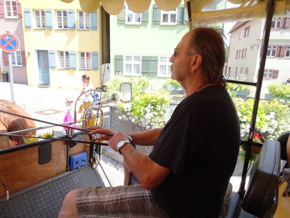
Our eccentric, beer-drinking and very personable waggoner-guide.

dsc00904.jpg

The picturesque hamlet of Raustetten. Our accommodation at the Waldeck Hotel is the building visible at the left edge of the village.

The fifth day of the Romantische Strasse took us from the hamlet of Raustetten south of Dinkelsbuhl, over a succession of easy paths 20 kms into the ancient town of Nordlingen. Walking conditions were perfect, with cool temperatures and motionless air under a hazy sky.

DSC00909

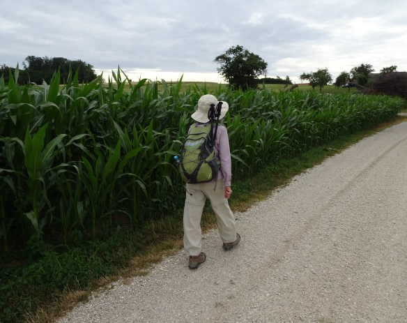
Easy walking on the morning of our last day…

DSC00930

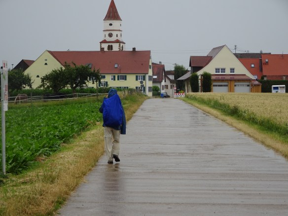
… but light rain joined us around 11:00 am and stayed with us for the rest of the day.

But around eleven o’clock small spots of rain began to tick against our faces. The hazy sky was still high and bright, but it cast a fine drizzle over us. We broke out our rain jackets and walked on, hunched under our backpacks like a couple of Quasimodos. The rain stayed with us until we reached the ancient, almost perfectly circular defensive wall around Nordlingen at three in the afternoon. We passed through an arched stone gate into the town’s glistening alleys. We had reached the end of the walk. We averaged 18 kilometres a day over five days.

DSC00906

The religious piety of former times is visible everywhere along the road between Dinkelsbuhl and Nordlingen. Here a forest sign reminds walkers that “God preserves the wilds and woods.” Or is it an entreaty? “God, preserve the wilds and woods!”

DSC00920DSC00917

DSC00922

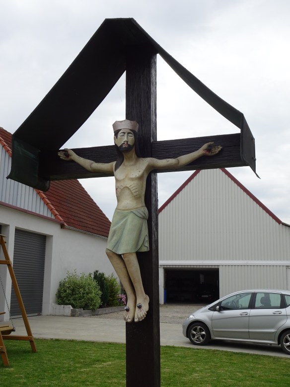
Here are just three of about a dozen wayside crucifixes on the path between Raustetten and Nordlingen. In the more secular 21st century, perhaps they are speaking to passing hikers. “You think you’re suffering? Look up here. You’ve got it easy, mate!”

Getting into Nordlingen was easy, but it proved hard to escape. The following day I went outside the town’s old walls to the railway station to buy tickets to our next destination, Zurich. The station was hard to find. Under a shroud of canvas behind temporary fencing, it was under reconstruction. It had been totally gutted. There was no ticket office behind the empty eyes of its windows. Amidst the scaffolding on the deserted platform stood an automatic ticket vending machine. Its instructions were all in German (abfahrt, fahrtkarten, bahnhof, gesamt) and I could not bring up Zurich on the screen. We trudged back into the centre of town and headed for the tourist information office.

“Can I go from Nordlingen to Zurich by train?”

The helpful matron behind the counter looked startled. She tapped at her computer.

“You can go by train from here to Aalen, then change to another train to Stuttgart, then change to another train to Singen, then change to another train to Zurich.”

I could see Emmy weighing our two big suitcases in her mind’s eye, then adding the heavy bulk of our backpacks. No way, she signalled to me.

The information officer looked at us with curiosity.

“Why don’t you just leave the same way you came?”

“We walked to Nordlingen from Rothenburg. It’s a long way. We’re not walking back!”

“You walked!?”

She was standing right beside a tall poster advertising the invigorating benefits of walking Germany’s Romantic Road. Evidently it was the first time she had seen a real Romantic Road walker. Perhaps she didn’t expect us to be grey-headed and wrinkled.

My solution was an expensive one. On Saturday, July 13th I hired a taxi to take us and our baggage the 100+ kilometres to Stuttgart Station where I was able to buy a train ticket direct to Zurich. Easy.

DSC00932

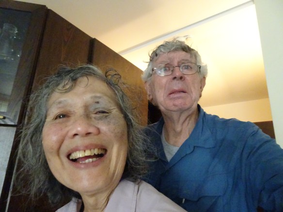
Arrival in Nordlingen. Emmy is thriving, while that shrivelled creature in the background is definitely struggling.

Advertisement

Queen Charlotte Track (3): Views To Die For, A Walk To Live For

The sun at my back and my shadow before me on the Queen Charlotte Track.

Emmy and I left Mahana Lodge around 8 a.m. and climbed a steep, winding gravel road some 1.5 kilometres to the top of the ridge about 200 metres above Punga Cove. Here we spotted the entry point to the next leg of the Queen Charlotte Track (41° 7’46.73″S, 174° 8’33.20″E) that would take us 23 kilometres south-west to Torea Saddle and our accommodation at Portage Bay. There was a disquieting notice beside the track… the walk to Torea Saddle, it told us, would take nine hours. Others might walk it more quickly, but for us this turned out to be pretty accurate.

The path runs along a ridge of land that falls away sharply to the sea on both sides. The isthmus is never more than about two kilometres wide (not counting several headlands that jut out into Queen Charlotte Sound). Nowhere along this segment of the track is the bush untouched by human enterprise and intrusive species. In the valleys at the northern end broad tranches of land have been cleared for pasture. On the slopes of the isthmus and on neighbouring necks of land there are extensive pine plantations blotched by commercial felling. In places gorse and broom, with their bright yellow flowers, grow profusely on the trackside interrupted here and there by the purple of thistles and the streaked white of eyebright. In Queen Charlotte Sound and adjacent Kenepuru Sound mussells are farmed. They grow on ropes that stretch between floats arranged in rows across the surface of the water.

Many valley floors have been turned into farmland.

Unsightly swathes of felled pine forest (centre and right) on a headland above Queen Charlotte Sound.

The track is well defined and the walking is easy, often over a soft mat of pine needles and manuka debris. There are several good inclines that will push air loudly in and out of your lungs and fill your ears with the thumping of blood. As we walked, we savoured the mild scent of manuka, and later – as the day warmed – the faint, refreshing perfume of pine. Tunnels of shade – busy with the zizz of a thousand insects – alternated with sections flanked with grass or beaten earth basking in yellow sunlight. Big black cicadas buzzed out of the trees and blundered into us, their wings fluttering momentarily in our ears or beating on our hats. In places they lay dead or fluttering on the path.

Picturesque walking amid stands of manuka (tea tree) forest.

There are two shelters like this on the leg of the track between Punga Cove and Torea Saddle.

It was a walk of panoramas. In the morning there were vast views over farmland sloping away to Kenepuru Sound on the north side of the isthmus. The Maori name for the South Island is Te Wai Pounamu, The Land of Jade Waters, and at the northern extremity of Kenepuru Sound the water is indeed a milky jade green when viewed from the hills above. By midday we were looking south over endless folds and scribbles of dark coastline inter-leaved with the shining waters of Queen Charlotte Sound and beyond. From time to time the snow capped saw-teeth of the Southern Alps shimmered on the horizon further south. Again and again we stood suddenly silenced by the rugged splendour of the vistas.

Looking south, the pounamu-tinged waters of Kenepuru Sound.

Spectacular views of headlands and water from Eatwell’s lookout.

There were close-up pleasures too. Twice we encountered wekas calmly walking the track ahead of us. They politely stepped aside into the bushes to let us overtake them. The weka is about the size of a fullgrown farmyard chook. It has fine plumage mottled in dark brown and light brown in equal parts. Like many of New Zealand’s native birds, it is flightless. As Emmy discovered at Mahana Lodge, wekas are inquisitive birds. They often snitch food and shiny items from human passers-by.

Fellow walkers: flightless, bipedal, largely defenceless, overly trusting, and liable to take things that don’t belong to them. Pretty much like human beings really.

The endearing, vulnerable New Zealand weka.

Shortly after midday we reached the first of two simple shelters located roughly one third and two thirds of the way along this segment of the track. It was equipped with seats, a bench, a toilet and a tank of rainwater. As we sat in the shelter munching on bread rolls a wild weka strolled in. Completely unafraid (though it took care not to come within grabbing range) it snacked for a while on crumbs from our bread rolls before stalking off into the shrubbery. It didn’t try to filch anything from us, but others have not been so lucky. In the guest book at the shelter one exasperated visitor had written “The bird steals everything!”

“The bird steals everything!”

A weka taste-tests Emmy’s lunch.

It was five o’clock in the afternoon when we emerged from the bush at Torea Saddle (41°12’19.80″, 174° 1’58.61″E). After nine hours of steady walking we were both weary. My feet were burning, Emmy’s left knee was throbbing. It was a luxury to trudge the last 800 metres downhill on smooth asphalt and to check in to our accommodation at The Portage resort (41°11’56.29″S, 174° 2’6.53″E, see http://www.portage.co.nz/). We settled into our small apartment and sat on the verandah taking in the views out to Kenepuru Sound in the warm, slowly dimming stillness of early evening. It had been a testing day’s walk but very satisfying, and more spectacularly beautiful than any walk I could remember.

A view to the south from the heights of the Queen Charlotte Track. The Southern Alps are partly snow-capped even in summer.

The following day, a Sunday, was a “rest day” (we really needed it). It dawned misty and cool. We spent the day reading, snoozing, and watching the constantly shifting light over Portage Bay. The clouds lifted, rolled and broke over the surrounding hills creating dramatic sky-scapes that changed almost minute by minute. Light rain began to fall. A couple of yachts twisted uneasily in the bay. The temperature dropped. We turned on the heater in our room.

The front garden at the Portage Hotel resort.

Our apartment at the Portage Hotel with views over the bay from the front verandah.

During the night rain fell steadily. It had eased by daybreak, but the weather was still threatening. If we walked the last leg of the track from Portage to Anakiwa, 23 km away, we would have to reach Anakiwa by 3.00 pm in order to catch the last water-taxi to Picton at 3.30 pm. Sunday’s rain – occasionally heavy – would have made the track, at best, slippery, and more likely boggy in places. There was a certainty of more rain ahead. Given our slow traversal of the 25 kilometres from Punga Cove to Portage two days before, we didn’t really need to think long about our plan for the current day. One of the gifts of old age (and there aren’t all that many) is that it becomes much easier to make discretion the better part of valour. At 11.00 am we were sitting in a water-taxi bumping over Queen Charlotte Sound towards Picton. We had walked a little under 40 kilometres of the 71 kilometre track.

The shifting moods of Portage Bay, overcast but clear…

… then within minutes misty rain rolls in…

… sunlight breaks through and lights up the sea…

… the clouds lift momentarily.

That evening we relaxed at Greg Thomson’s Fernview B&B. Greg and I exchanged reminiscences about our eating adventures walking the Camino Portugues (see Greg’s Camino blog at: http://www.caminoportugal.blogspot.com.au/ and my review “From a mini masterpiece to a wallowing hippopotamus” posted July 21, 2011 in this blog) before Emmy and I headed into town for an evening meal at the Sea-Breeze Café and Bar. I wolfed down a plate of fish and chips (what else?) while Emmy did a good job of demolishing a brick-sized slab of blueberry cheesecake. The proprietor sang slow, sentimental songs at the café’s piano. A cool twilight descended on the largely deserted streets of Picton. New Zealand’s changeable weather had made the Queen Charlotte Track an unpredictable, and therefore especially memorable, experience. We vowed we would be back for more – and soon.

Picton’s quiet waterfront on our last evening in the Marborough Sounds. In the background our ferry waits for next day’s trip across Cook Strait back to Wellington.

Photographs can’t do justice to the natural splendour of the Queen Charlotte Track.

Queen Charlotte Track (2): Recovery

While Emmy was sleeping off her sea sickness I made a quick excursion to a waterfall about a kilometre away on the hill above Furneaux Lodge. Well… it was supposed to be quick, but the path was difficult and ultimately it took me about three hours to walk to the falls and back.

But it was worth it. The bush was largely (but not completely) pristine native bush. There were tangled skeins of black, woody, supplejack vines (kareao in Maori). In some places they lay on the ground like electric power cables waiting for a walker’s boot to trip over them. It was these vines that in childhood my friends and I prized above all plants. If we found a suitable one we made it into a tough bow and fitted arrows to it made from straight stalks of bracken.

Supplejack vines lie across the path like electric cables.

Like an anaconda snake: a tree root on the path

Everywhere there were thickets of silver fern (ponga) with fronds that were green on the upper surface and silvery white underneath. These are the plants that – besides the kiwi – have become an almost universal symbol of the New Zealand nation, decorating the playing jersies of the god-like All Blacks in particular. But the ferns are not mere mythic symbols, they really exist, and here they are abundant.

Green on top, silver underneath. New Zealand's famed silver fern.

Dry fern fronds hang like exotic necklaces.

There were spindly, black-trunked tree ferns (mamaku), many rising as high as coconut trees. In places they stood in dense clusters with whorls of foliage overlapping in lush profusion as in a prehistoric forest. Here and there a mamaku had crashed to the ground, the hexagonal markings on its trunk like the scales of some eerie black python.

Mamaku ferns stand as tall as tropical coconut palms.

Prehistoric forest habitat... once inhabited by the three-metre tall moa?

Like a scaly fossilised python, a fallen ponga trunk stretches out across our path.

Tea tree (manuka) shrubs were prolific, some forming tunnels of grey trunks and grey vegetation over the path. A few displayed the small white flowers that produce New Zealand’s famed manuka honey. Manuka honey is said to have anti-microbial properties. It is effective as an antiseptic on skin lesions. My favourite toothpaste is New Zealand-made Red Seal Propolis toothpaste infused with honey extract (though I’m not sure whether the extract is manuka honey). The packaging claims it sweetens the breath and keeps gums in good shape, and I think it does.

Queen Charlotte (before she had her 15 children, presumably). Wikipedia image..

The next day, Friday March 9th, Emmy bravely hoisted a backpack on to her back and we set off on the 14 kilometre segment to our next stop, Mahana Lodge at Punga Cove. The track took us around the densely forested shoreline of Endeavour Inlet, named after the ship captained by James Cook when he “discovered” and named Queen Charlotte Sound in 1770 (he stopped by again in 1777). By the way, Queen Charlotte was the German-born wife of King George the third who ruled the United Kingdom from 1760 to 1820. Queen Charlotte gave birth to 15 children and stoically tolerated her husband’s bouts of insanity made famous in Alan Bennett’s play The Madness of King George III (which Emmy and I saw in Bath, England, last year – great show!). Of course, there is a bizarre disconnect between a wild and beautiful arm of water in one of the world’s most remote archipelagos, and a king’s consort who patronised Mozart and Handel in her salons at Buckingham Palace. But history has a habit of smoothing out the jolt of these disconnects and today nobody thinks twice about the powdered, bewigged and bejewelled lady whose haughty face stands behind the name of the sound.

On the track between Furneaux Lodge and Mahana Lodge: a view over Endeavour Inlet.

Fourteen kilometres is not a long stretch but we took it slowly. It was around 3.00 pm when we ambled in to Mahana Lodge (41° 7’52.40″S, 174° 9’14.36″E, see http://www.mahanalodge.co.nz/) to a wonderfully warm welcome from our hostess, Ann Martin. She conducted us to our accommodation, a comfortable cabin behind the main buildings of the lodge. We stretched out on the comfortable bed. On the opposite wall a window looked into a profusion of branches and leaves alive with tiny birds. Around us the forest buzzed and hissed and clicked in the late afternoon warmth. We soon sank into a deep sleep.

Our bush-clad accommodation at Mahana Lodge.

Much better than TV: our personal window into the bird-filled bush at Mahana Lodge.

Dinner was served at 7.00 p.m. in the fading light of early evening. The lodge’s ten guests assembled around a long table in a semi-outdoor garden conservatory. John Martin put on a spectacular display of culinary magic, all home-cooked and (mostly) home grown. I had flavoursome venison patties served on a bed of sweet potato (kumara) mash. Emmy (her appetite suddenly reawakened) tucked into a crispy home-baked chicken and mushroom pie. The side dishes of juicy salad – pulled straight from John’s garden just minutes before – were garnished with the mild, delicious bite of bright red nasturtium petals. Home baked bread and a caraf of Marlborough pinot noir kept the conversation flowing well past nightfall.

Walkers seated for dinner at Mahana Lodge.

Venison patties on kumara mash with (right) chicken and mushroom pie and (centre) nasturtium-decorated salads: our delicious meal at Mahana Lodge.

The following morning, as we checked out, Emmy asked Ann about a mystery that had made her look around nervously the previous night.

“Yesterday afternoon I took off my boots and left them on the verandah outside our room. A little later I found that one of the boots had moved… it was lying under a nearby table and the sock was missing. I went searching for the sock and found it in the garden around the corner at the side of the cabin. How could that happen?”

Ann laughed. “It must have been a weka. There are lots of them around here.”

A weka? I had a vague memory of a small, fat, flightless bird. Later in the day we were to see more – much more – of these endearing but kleptomaniac little creatures.

Queen Charlotte Track (1): A Rough Beginning

The Marlborough Sounds are at the northern end of New Zealand’s South Island. Its narrow channels of water lie between fingers of land that reach like a badly deformed arthritic hand into the waters of Cook Strait. The walk runs for 71 kilometres, from north to south, down one of these fingers (see http://www.qctrack.co.nz/about/). Normally walkers complete the trip in four days. Having little information about the rigours of the walk, Emmy and I decided to take no chances and complete the walk in five days with a one-day recovery break at The Portage resort after the track’s longest segment. We decided to stay at lodges along the way, with our bulky luggage transported from lodge to lodge by water-taxi. Arrangements were made for us by Greg Thomson of Natural Encounters (see http://www.natural-encounters.com/), one of several local companies that offer a variety of support services for walkers and cyclists.

Emmy and I were on the interisland ferry Aratere as it glided quietly out of Wellington harbour on the afternoon of March 7th. We found a seat in the forward lounge where there was a good view over the bow into the tumbled, white-capped expanse of Cook Strait. The sea was rough (at least it seemed so to us landlubbers) but the ship hummed under us with remarkable steadiness. An overcast sky hid the horizon. It was an hour before the South Island – only 25 kilometres from the North Island – eventually emerged. From a ghostly outline it slowly came into focus, a barrier of dark hills directly across our path.

Slowly the South Island emerges from a hazy horizon.

The ferry heads straight towards a barrier of dark hills.

Somehow a chink opened up in the pallisade (Google Earth: 41°12’38.57″S 174°19’5.62″E) and we squeezed through into the flatter waters of Tory Channel. Half an hour later we turned into Queen Charlotte Sound and headed into a strong, chill wind gusting up the narrow trough of water from the cloud-cropped hills to the south. Fold after fold of headland jutted into the grey satin of the the fjord. Silence fell over the passengers as they watched the patchwork green slopes flow past on both sides of the ship.

Looking down Queen Charlotte Sound into the teeth of a chill southerly wind.

Bush covered hills slide past as the ferry nears Picton.

The ferry swivelled and reversed into its berth in the small town of Picton. As arranged, Greg Thomson, our host from Natural Encounters was waiting for us outside the arrivals lounge. He whisked us immediately to our very comfortable accommodation just five minutes away at the Fernview Cottage B&B. Here we relaxed into a simple but tasteful and quiet colonial ambience maintained with careful attention to detail (the peach-coloured roses in our room were real!).

As the long afternoon faded we walked into the centre of Picton in search of dinner. The blustery wind had intensified. Flags in the main street were shaking hard. In the waterside park the branches of pohutukawa trees were bobbing and writhing. A dark cowl of clouds hung over the almost deserted town. We found a haven of warmth in the Café Cortado where we demolished a big meal of fish and chips.

Picton’s Cafe Cortado: a haven of warmth and good food on a cold evening.

Fish and chips for dinner. This is Marlborough, so naturally your fish and chips are served with a glass of world famous Marlborough sauvignon blanc.

The following day – the first day of our walk – the weather was worse. The water was rough on the normally placid sound. Wind was still pouring over Picton like an enormous jet of water, scouring the streets, flattening trees against hillsides like waterweeds in a fast current. We had a water-taxi trip of 35 kilometres ahead of us to the start-point of the walk in Ship Cove at the northern end of the sound. It took well over an hour to get there as the boat bounced and slapped over the increasingly jumpy water. Emmy, who was already ill from a dud meal she had eaten on our flight from Sydney, quickly became sea sick. Queasiness overtook the other passengers too, but the driver of the water-taxi insisted on being cheerful. He force-fed us with facts and figures about the places we passed. “Tory Channel,” he shouted over the roar of the boat’s engine, “was the second most populated place in New Zealand between 1840 and 1860.”

Ready to go… inside our water-taxi on Picton’s waterfront.

Fortified by this useful information (and much more) we made it to the northern end of the sound. But a planned stop at Motuara Island – a carefully protected sanctuary for native birds (location at 41° 5’42.27″S, 174°16’27.51″E) – had to be abandonned. The sea was too rough to permit the water-taxi to berth. At Ship Cove a small cohort of walkers gratefully disembarked, but Emmy sat with her head down retching into a waste paper bin. The first sector of our walk was clearly off the agenda. We stayed on board and headed for our first night’s accommodation at Furneaux Lodge (41° 5’33.79″S, 174°11’14.01″E see http://furneaux.co.nz/) a couple of headlands away from Ship Cove.

Battered by rough seas on Queen Charlotte Sound…

… and Emmy finds it tough going.

Emmy walked unsteadily along the jetty and into the bar at Furneaux Lodge where she slumped into a pew-like seat and laid her head on the table. Even at 11 o’clock in the morning apparently this was normal behaviour for guests so her plight didn’t attract much attention. But as soon as the staff realised she was ill, not hung-over, she was hurried to a hastily tidied guest room and tucked up in bed.

Furneaux Lodge: a haven of good food and bushland quiet.

The cabins at Furneaux Lodge where we were shaken by a short, sharp earthquake.

The wind slowly abated and the sky began to clear. By evening we were both ready to eat. In the Furneaux Lodge restaurant, under sloping glass panels that gave us a restful view of the sky and bush, we enjoyed a meal of grilled salmon fresh from the waters of the sound, with local vegetables and a glass of delicious Marlborough sauvignon blanc.

Later that evening we had a characteristically NZ experience to bring our first day to a close. Just after 8.00 pm a short, sharp earth tremor shook our semi-detached cabin. It was like a sudden angry gust of wind that slapped the room hard, rattling the beams and slamming shut the bathroom door. Outside all was serene. It was a good, invigorating shake that set our hearts thumping for a few moments. The following morning we learned that the epicentre of the quake had been under the sea about 40 km north-west of Paraparaumu on the west coast of the North Island. The quake measured 4.9 on the Richter scale.